
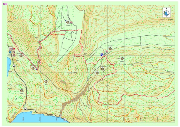
Kalkan-Bezirgan-Sarıbelen
One could proceed 3-4 km through the asphalt from Akbel to Bezirgan with a view of Kalkan. By turning left from the old water cistern on the road, an inclination begins towards the hilltop from the stony pathway with zigzags. This could be a steep and tiring climb. After the peak and walking from stony pathways, old but still usable granaries can be seen. You can proceed on the asphalt until Bezirgan village square.
Drinking water can be obtained after Kalkan district only from the fountains in Bezirgan. Also there is a market at the center for basic shopping needs. Then there starts a climb from Bezirgan towards the main road. After proceeding towards the TV transmitter from the dirt road near the main road, and after walking for a while you can pass to pathway from the dirt road and then the descend starts from among the shrubberies. Lycia road signs were partly erased in this section.
When you reach again to asphalt after going around, Lycia road sign could be seen. Among the crops one could proceed towards Sarıbelen. There is a fountain and a market in Sarıbelen settlement. The road connects to asphalt again after leaving the asphalt via a pathway climbing towards the upper section of the village. After proceeding for a while you could reach from the pathway to the hilltop from the right side of the road. After a short forest area you reach to the flat area behind the Alacaambar hill. The pathway then connects to the dirt road and then inclines and after passing a couple of flat areas and pens go on towards Gökçeören by passing small hills and flat areas.


TUMİNEHİ /TYMNESSOS (BEZİRGAN)
Researches made has shown that the ruins in Bezirgan belongs to the Tuminehi settlement in Lycia sources and Tymnessos settlement in Greek and Roman sources, and that Kalkan is the port of Tuminehi.
Tuminehi is a mountainous settlement at 1000m height from the sea level which has a very fertile valley and rich water sources among the hills and the mountains. Ancient settlement which has a strategically important location had controlled a narrow pass located between Xanthos and Phelos on a main trade route with a long time regiment located at the castle on the highest point in the settlement. Acropolis is located 300m down from this point. The area between these two points is thought to have contained the holy area with the ruins of a church set up in high terraces. The city is located between acropolis and the abovementioned pass, was destroyed because of erosion and unlicensed excavations.