
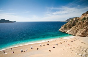
| Kaputaş Beach One can reach this beach from Kas via the scenic Kalkan road by 20 minutes drive. There is a long stair way down to this sandy beach with white-crested waves and magnetizing turquoise color sea.There are no facilities in the beach and the open secret about the stunning turquoise color is the snow-white pepples covering the sea floor. |
 |
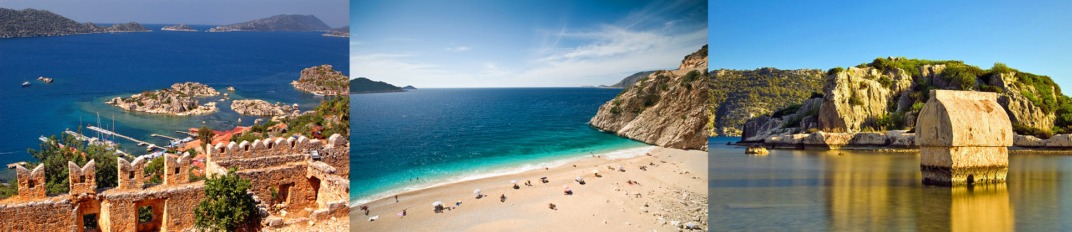
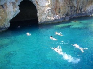
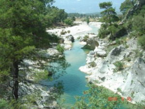
| Blue Cave The Cave was first discovered in year 1972. It is one of the most famous anchoring points of tour boats around Kas, with a 50 m length, 40 m width and 15 m height. It was a habitation for the seals in the past. Because of the narrow entrance the sunlight fogged in through the sea creating joyfull lighting effects and reflections inside the cave walls and ceiling, It is very close to Kaputas Beach and only 18 km to Kas. |
 |
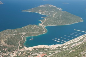
Çukurbağ Peninsula For a more silent, tranquil and peacefull holiday most of the holiday makers prefer Cukurbag Peninsula which is 6 km away from Kas. There are boutique hotels, villas and luxury facilities on both coasts of the peninsula. As being quite dark at night without any electricity pollution it is a very nice place for staring at stars. Leisure boats and yatchs prefer to stop over around the peninsula for its crystal clear waters during the day to experience the serenity of deep blue. Between Kalkan road and Peninsula lays a natural bay called Bucak Sea and also the new marina. Meis Island Meis is just 20 minutes away from Kas with a boat trip. Only 400 people live in this Island. It is connected with Rhodes by ferry and is served by small Kastellorizo airport. On the other hand, the closest link to the rest of the world is mainly Kas. Every Friday the residents of the island travel to Kas and visit the local Friday market. Only settled area existing on the 3, 7 square meter island is Kastellorizo village. After St. John Knights the island was conquered by Egypt Sultan, King of Naples, Ottoman Sultan and etc. Kastellorizo was assigned to Greece in 1947. The island has become more popular in recent years among tourists looking for an isolated place and also thanks to the Oscar-winning movie Mediterraneo. Sponge fishing is the supreme livelihood besides cultivating vine and olive trees. If you have a green passport you can visit the island without a visa or else you will need a Schengen Visa. |
 |
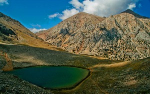
Gömbe Being one of the most famous and chilly mountain pasture used in summer Gombe is well known with its delicious apples, walnuts, pears, traditional greased wrestlings , hospitality and friendly people. It is an escape for those who swelter in the mid of summer. During your 70 km driving to Gombe red pine, cedar, juniper trees and squirrels guide you. You can also reach Gombe via tours organized by agencies in Kas. One can fish in Gombe Dam, and swim in ice-cold, crystal clear Yesil (Green) Crater Lake whose water is also drinkable. There is also a 60 m high water fall called Ucarsu which is very close to Yesil Lake. Taking a short walk to take some photos of this water fall coming down from the tips of Akdag Mountain is also a special occasion. In between 5th June – 7th June there is “Ucarsu Festival” during which local people offer sacrifices, folklore shows and whirl performances and visit Abdal Musa Dervish Lodge. There are also several other seightseeings around like Subasi Prairie, Ikiz Goller (Twin Lakes), Yesil Barak Village which is famous with its natural madder rugs. Memorable tastes like“Gombe Kebabi (Kebap)” and “Gombe Coregi (Bun)” could be found in most of the restaurants near the riverside. Specificity of “Gombe Kebabi” is the very slow cooking of delicious and fresh meat of capricornsgrown in the prairie, in stone ovens. |
 |
Xanthos Being one of the ancient Lycian cities with 3 vote’s right, it is located on a tip close to Esen stream, within the limits of Kinik Town. The city name is said to be “Arnna” in old tablets from Lycians. Besides its archeological importance Xanthos is also honored with its people’s passion for independency who mass-suicided during wars against huge besieging forces of Persians and Romans. During your visit you can see, Lycian period home type stone tombs, steles, sarcophaguses, engraves and an inscripted upright sarcophaguse which is now an important document for Lycian language. |
 |
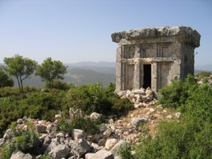
| Phellos It is an ancient city with a unique scene situated on the north of Kas (Antiphellos) and 2 km away from Cukurbag Village. Ruins are mostly sarcophagus type tombs which can be seen on a narrow and long tip. On the highest point of this tip a home type stone tomb bathed with walls stands out. With its rich engravings the tomb is an authentic example of its kind. |
 |
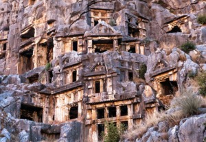
| Demre (Myra) Myra is an ancient town in Lycia where the small town of Kale (Demre) is situated.It was one of Lycia’s six important cities and a prominent Christian center. Known history dates are back to the 3rd century BC. St.Nicholas (Santa Claus) had been prelate in the beginning of 4th century in Myra. It boasts the best examples of Lycian household graves and rock tombs. The theatre of Myra is gone into divisions as east and west metropolis.St.Nicholas Church is also one of the important places to visit. St Nicholas has been memorialized every year on 6th of December with events in Demre. |
 |
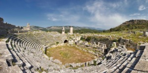
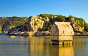
Üçağız, Kaleköy, Kekova Kekova is a natural paradise blending nature and history along the clear, turquoise shore.Kekova includes Ucagiz (Theimussa) on the shore, Kalekoy (Simena) which is accessible by boat and Kekova Island with Sunken City. Kekova Island (Sunken City) has not had city characteristics like two harbour towns opposite,but it protects the towns from Mediterranean Sea and was a port for sailors,also dockyard for building and repairing their boats. Boats dock at the island in Tersane Bay. There are many ruins on the island, stairs lead down from the shore to the Sunken City which is visible under the clear water. Sunken City which had been used as commercial and military station at least since 5th century BC is the most colourful corner of Kekova region. Simena (Kalekoy), built over the ruins of ancient Lycia, is only accessible by sea from Ucagiz. Kekova is a protected area because of its history. There are islets having tombs and was used as quarry between the island and habitation.Simena, with its secured middle age castle which has an excellent view of Kekova Island and the beautiful bays below,had been mentioned in ancient sources of 2nd century A.C. for the first time.Inside the castle, seven rows of seats forming a 300 seat theater have been carved out of the natural boulder. Along the shore are many household graves and a bath with inscription. North of the tower is a household Lycian grave with an inscription which is worth seeing. Theimussa (Ucagiz) is surrounded on three sides by the sea like a natural harbor. Habitation of today’s village is over the small Lycian harbor town. The city’s ancient history is limited but one inscription indicates that it was founded at least by the 4th century B.C. There are many ruins of graves, a small door and a tower built on a boulder in the village. |
 |
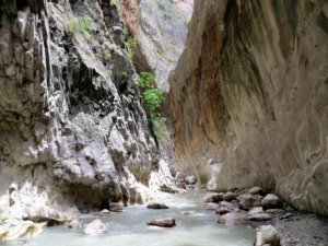
Saklıkent Canyon The natural wonder,Saklikent (Hidden City),60 kilometers from Kas, is reached by crossing a 100 meter wooden bridge over the canyon. Natural border between Kas and Fethiye, Karacay’s water source is this canyon. Saklikent is the longest canyon with its 18 kilometers length and is accepted as one of the wellknown national parks of Turkey. 6 km of the canyon is good for hiking. This huge gorge was cut out of the mountain by an earthquake hundreds of years ago. A river runs through the gorge which you can walk along, following the mountain wall on a suspended walkway. During the summer months you can wade through the icy cold waters from the melted snow on the nearby mountain tops and take in the breathtaking scenery. It is nearly impossible to go out from the canyon without being wet. You can also have a rest and enjoy local meals in the restaurants’ wooden balconies after your adventure in the canyon. |
 |
İslamlar Village The village which is 30 kilometers away from Kas is popular with white grapes and trout fish.Turks and Greeks have lived in this village together for several years.The old Greek name of the village was Bodamya which means rivers. Streams all over the village let you have a breath as in an oasis during very hot summer days.There is a 300 years old water mill from the Greeks.There are some Lycian rock graves by the mountainside. In Goldag Region you can see enormous inlaid rock graves. The village is famous for its many trout farm restaurants. These cosy restaurants provide all kind of traditional starters (meze), foods and also breakfast in Islamlar where offers peace and tranquility in a cool atmosphere during hot summer days overlooking Kalkan. |
 |
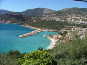
Kalkan (Kalamaki) Kalkan where historian Herodot said about that “The nearest place to the stars” has been a safe and important harbor throughout history for the agricultural and forest products’ marketing and shipments coming from Elmali-Gombe-Bezirgan regions. Kalkan was an important harbour town until the 1970s as the only seaport for the environs. It declined after construction of Fethiye road but revived after the emergence of the tourism industry in the region. It is famous for its white-washed houses and called as Kalamaki when it was an old Greek fishing town till 1920s.The church remained from the Greeks is used as a mosque nowadays. British newspaper The Independent listed Kalkan among the best tourist destinations for 2007. The paper recommended Kalkan especially for those seeking a romantic vacation and who do not want to travel far from their home country in Europe. We suggest you to visit Kalkan, which is also called as “Terrace Paradise” because of the several restaurants located on terraces with amazing sea views and sunsets. |
 |
| Dirgenler Village The name of the village comes from the workers who use pitchfork (dirgen). It is located in Kasaba valley and 35 kilometers far away from Kas. The village people live off greenhouse cultivation and there are marble quarries and marble factory.The hospitality and the sincerity of the village people double the beauty of the history and the nature. Sisama Church that is one of the seven Byzantine churches built after Justinian and Dirgenler Castle are worth a visit. The church is one of the most beautiful examples of the Domed Basilica style. |
 |
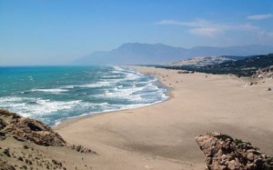
Patara The ancient city which is located 41 km. from Kas, was the capital of the Lycian Union. The council meetings of the union were held in Patara and Patara held the right of using three votes. Its history dates at least to the 8th century BC. The appearance of the Patara port has been caused by silt deposits brought by the Xanthos (Esen) Creek. Being a protected port along the Mediterranean trade routes was one of the important features of the city. The name Patara is still attached to the numerous ruins of the city. These, according to the survey of Capt. Beaufort, are situated on the sea-shore, a little to the eastward of the river Xanthus, and consist of a theatre excavated in the northern side of a small hill, a ruined temple on the side of the same hill, and a deep circular pit, of singular appearance, which may have been the seat of the oracle. The town walls surrounded an area of considerable extent; they may easily be traced, as well as the situation of a castle which commanded the harbour, and of several towers which flanked the walls. On the outside of the walls there is a multitude of stone sarcophagi, most of them bearing inscriptions, but all open and empty; and within the walls, temples, altars, pedestals, and fragments of sculpture appear in profusion, but ruined and mutilated. The Patara Beach, 18 km long and 280-1500 meters wide, is Turkey’s largest sandy beach. It is also the breeding ground of the delightful Caretta-Caretta sea turtles, so during the breeding season their area is carefully protected by the Ministry of Enviroment and Forestry. |
 |
SourceLink: hestiaturkey.com